
Located in the states of Idaho, Montana and Wyoming, Yellowstone National Park became the first national park in March of 1872. From its unique geothermal features (over 10,000 geysers, hot springs, mud pots and fumaroles) to its endless amount of wildlife (almost 400 different species of animals!), to its unbelievable landscape (countless lakes, rivers, mountains), it truly is a spectacular place. Also, unlike many other spectacular places, Yellowstone’s beauty is much more accessible since many features can be seen by just taking a few steps outside your car instead of having to hike many miles into the wilderness to see something phenomenal, which is kind of awesome😊 Now if hiking, biking, swimming, boating, fishing, horseback riding, skiing or snowshoeing is your thing- they have that too! I’m pretty sure you could spend months at Yellowstone and not run out of things to do. Below I’ve included a 4-day itinerary because I do think you need at least 4 days to hit all the major areas and not feel super rushed. Plus, that would leave you three days to hop down to Grand Teton National Park which is only 8 miles south of Yellowstone’s South Entrance. Please reach out if you plan on staying more or less days and I’d be happy to give you suggestions😊
Entrance Fee: $35 per vehicle (private, non-commercial) for 7 day pass
Lodging: Yellowstone has 9 lodges inside the park that offer a variety of hotel or cabin style rooms, and 12 campgrounds. Reservations for all lodge rooms on site and for 5 of the campgrounds (Fishing Bridge, Canyon, Bridge Bay, Grant Village, and Madison) can be made here- Yellowstone Lodges. 3 of the other 7 campgrounds (Pebble Creek, Slough Creek and Mammoth Campgrounds) take reservations at Recreation.gov. The remaining 4 (Tower Fall, Indian Creek, Lewis Lake, Norris) do not take reservations, currently. For campgrounds, this link is a great resource to determine daily availability and closures- Yellowstone Camping.
Dining: There are dining options and general stores in every main area of Yellowstone during the summer months. During the winter months there are only dining options in the Old Faithful and Mammoth Springs areas. For menus, hours and closures check out this link- Yellowstone Dining.
Must Know Before You Go:
1. If possible, I highly recommend staying on site. West Yellowstone, Island Park, Big Sky (these are the ones I have personal experience with) and many other towns are lovely areas surrounding Yellowstone but getting in and out of the park every day was not our favorite experience and was a little bit of a patience tester. When we went this past summer, it took us about 1-3 hours every single night to go 14 miles to get out of the West Entrance. Every evening there are herds of elk on the side of the road there and every evening you have a significant number of cars that will stop in the middle of the road instead of using pull offs or parking lots. If you’ve ever driven the West Entrance Road, it is almost comical how many pull offs and parking lots there are (because the area is gorgeous!) making it doable for anyone to watch elk, for as long as they want. But, I just want to be perfectly honest, so you are prepared- most people don’t do that, and you are very likely to spend the night waiting in traffic. The upside is, the scenery and wildlife on this road are really spectacular, which makes it way more enjoyable than a regular traffic jam😊
2. *Traveling in Yellowstone, as always, at any park, is at your own risk. To hike safely, I strongly suggest having bear spray and knowing how to safely use it. I would also watch all wildlife and bear safety videos on the National Park Services website. We even had our kiddos watch them before going. Wildlife Safety Videos.*
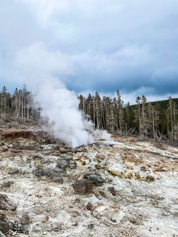
3. *Yellowstone is filled with so many awesome geothermal areas that it is also imperative for your safety and the delicate formations that you stay on all trails and boardwalks and not touch any thermal features that can get up to 450° F! The boardwalks and trails also keep you on stable ground in an area that can be unstable.*
Cell Service: Cell service is very limited, especially on trails. We found the best service to be in the Mammoth Hot Springs and Old Faithfull Areas

Day 1 (West Yellowstone)
Old Faithful- Old Faithful is one of 9 geysers at Yellowstone that the park tracks and can predict eruptions. The eruption times can be found on the Yellowstone NPS website with a 10 minute plus or minus margin of error (https://www.nps.gov/yell/planyourvisit/exploreoldfaithful.htm). You will want to get there early because parking and finding a spot on the viewing boardwalk can be tricky since this is an area with large crowds. At this time, you will also run into construction both getting in and out of the Old Faithful area. This area does have plenty of food options, shops, a visitor center and even a place to get gas if needed so there is plenty to keep you busy if you arrive early!
Upper Geyser Basin Boardwalk to Morning Glory Pool- After we watched Old Faithful erupt, we started on the boardwalk to the east of Old Faithful. When the boardwalk splits at Sulphur Spring we took the southern part of the loop to head up to Morning Glory. You will continue that path until you get to a split just past the Lion Cub Group. Turn left (or northwest) to continue on the right path. Once you come to the paved path, turn right to continue north to the Morning Glory Pool. The Morning Glory Pool will be at the very end of the paved path. Roundtrip, this trail will be 3 miles. It did take longer than our usual 3 miles only because there is so much to see along the way! Plus, the Morning Glory Pool is spectacular (despite its fading beauty from past vandalism) and you won’t want to miss it! There are restrooms near the pool at your turn around point.
Observation Point- We grabbed some lunch near the visitor center and then headed to the Observation Point Trailhead (you would have passed this on the last trail, it’s just to the east of Old Faithful). This 1.5-mile roundtrip trail will take to some stunning views of the entire Upper Basin. And if you plan it right, it’s another great place to watch Old Faithful erupt for a second time. There are elevation changes, but the switchbacks make it more doable and gradual for all ages.
Grand Prismatic Overlook- For this trail, park in the Fairy Falls Parking Lot. This lot is not well labeled so if you start seeing the actual Grand Prismatic Spring from the road, you’ve gone too far on Grand Loop Road. Coming from the Old Faithful area the parking lot will be on your left. Once parked, look for the bridge, cross it and make your way up to the overlook. It is 0.8 miles, uphill, to the amazing view.
Fairy Falls– After the overlook, we continued the same trail to Fairy Falls, which is another 1.5 miles past the overlook. This hike will be 5 miles roundtrip (including the hike to the overlook). We are big fans of waterfalls in our family so we loved this hike and it was definitely a must see for us!
Grand Prismatic Spring- The Grand Prismatic Spring is Yellowstone’s largest hot spring! It’s massive size and vivid color makes it quite impressive. Parking for this spring is not far past the Fairy Falls Parking lot. It’s a short walk down the boardwalk to the beautiful Grand Prismatic Spring and a few other spectacular sights!
Gibbon Falls- These falls are right on your way to Norris Geyser Basin, about 15 miles from the Grand Prismatic Spring. There will be a parking lot on your right, and a short walk to the overlook of the beautiful 84ft falls.
Norris Geyser Basin- After Gibbon Falls, stay on Grand Loop Road to Norris Geyser Basin (about 9 miles past Gibbon Falls). There is a small museum, bookstore, and restrooms in this area. There is also a large parking lot but even later in the day we had about a 20 min wait to even get in the lot. This area is truly beautiful, especially in the evening, so it was worth the wait! I also highly recommend donating the $1 for the Norris Geyser Basin booklet. It will make finding your way much easier!
Back Basin (Long Loop)- We started this loop between the bookstore and museum, so our first stop in the Back Basin was Emerald Spring (one of my favorites😊). We stopped at the Steamboat Geyser next and then took the loop all the way to the Green Dragon Spring where you loop around and start heading back towards the museum. This trail ends on the north side of the museum where you can pick up the Porcelain Basin Loop. Most of this trail is boardwalk, but there are plenty of stairs so many parts are not stroller or wheelchair accessible. The long loop in the back basin is 1.6 miles and took us about 40 minutes to complete.
Porcelain Basin (Long Loop)- The Back Basin Loop will drop you off right in front of the Porcelain Basin Loop. We went counterclockwise so we started on the trail to the right(south) of the overlook if you are coming off the Back Basin Loop. This trail is mostly paved or boardwalk but again, has many steep grades and stairs so I would not bring a stroller. This long loop is 0.6 miles and with plenty of stopping for pictures took us about 20-30 min to complete. After Porcelain Basin it was time to head back for the night!


Day 2 (North Yellowstone)
Mammoth Hot Springs- Mammoth Hot Springs can get very congested so it’s a great place to start early in the morning before it’s too crowded and too hot (there is little to no shade). This area has the Albright Visitor Center, plenty of restrooms, food options, and picnic tables.
Upper Terrace Drive- The first thing we did at Mammoth Hot Springs was the Upper Terrace Drive. It is right off Grand Loop Road and will take you past several very cool terraces and springs on the 2-mile scenic loop.
Boardwalk through Mammoth Hot Springs- Next, we drove down to the main area to walk the boardwalk through the Upper and Lower Terraces. There are parking lots at both the Upper and Lower Terraces if you do not want to tackle the stairs, but we just parked in the main area at the Lower Terraces and walked the entire boardwalk. The boardwalk in its entirety is just under 2 miles, but there are multiple directions you could choose to go, so it may be slightly longer or shorter depending on the route you choose. I would highly recommend grabbing a trail guide prior to heading out, they are super helpful!
Undine Falls- About 4 miles past Mammoth Hot Springs, on Grand Loop Road, is a small parking lot that has a short set of stairs leading to a gorgeous overlook of Undine Falls. This 60 ft waterfall is definitely worth a stop!
Lava Creek Trail- A half mile after the overlook is the Lava Creek Picnic area which is a great place to stop and eat lunch. After lunch, we headed out on the Lava Creek Trail from this area. The entire trail is 4.2 miles one way, ending with a footbridge going across Gardner River near the Mammoth Campground. With 3 little ones and a lot more to see today we walked 2 miles in and then 2 miles back out. It was still a great hike, with awesome views! If Tower Fall and Dunraven Pass are closed when you go (the road to both is currently closed for construction), I would recommend the entire hike!
Wraith Falls- Another 0.5 miles down Grand Loop Road is the Wraith Falls Trailhead. This trail has you hiking through a beautiful meadow full of wildflowers, through a forested area, and crossing the lovely Lupine Creek to the 79ft Wraith Falls. This easy, 1 mile roundtrip trail is excellent for all ages and took us about 40min to complete😊
Petrified Tree- Another 12 miles down Grand Loop Road will be the turn off to Petrified Tree. The sign for the turn off is very small and easy to miss, but it will be on your right-hand side if you are traveling on Grand Loop Road coming from Wraith Falls. Once parked, the tree is just a short walk up a paved path to the 50-million-year-old tree!
Lost Lake Trail- This 2.8-mile loop trail can be picked up right at the Petrified Tree parking lot. It can also be picked up behind Roosevelt Lodge farther down the road but since we were already here and parked it was easy just to pick up the trail from here. We did see a bear and bison on this trail, and the ranger said there were other bears in the area as well. I would definitely not forget your animal safety tips or bear spray when traveling the Lost Lake Trail. This trail did have some elevation changes, but overall an easy hike.
Lamar Valley- This area is stunning as you drive along the Lamar River and take in all the beauty. And oh my goodness…animals, animals and more animals for miles and miles. We saw everything- bison, bear, badgers, wolves! It was so amazing😊 To drive from the Tower-Roosevelt junction to the Northeast Entrance is about 28 miles one way and would take you about 40 min one way with no stops (which is unlikely). Roundtrip it took us just about 2.5 hours and we stopped many times for pictures, animal sightings and to stretch our legs.
*Tower Falls, Mount Washburn and Dunraven Pass areas would be your next stops in North Yellowstone, but at this time they are closed because the road between Tower Junction and Canyon Village is under construction. Also, because of where you are in the park if you are staying on the west or south side of the park it will take some time to head in for the evening so there won’t be much time to add on extra activities because unfortunately with that road closed traffic on the north side of the park is not ideal. After April of 2022, I would add them to the end of this day if time allows.


Day 3 (East Yellowstone)
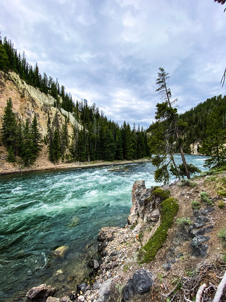
The Grand Canyon of the Yellowstone River- This area was one of our favorites! As I have said before, our family loves waterfalls and this area has plenty😊 And who knew there was another Grand Canyon?? This Grand Canyon is up to 1200ft deep and 4000ft wide and over 20 miles long as the impressive Yellowstone River runs through it. We explored both the North and South rim areas and trails, but I would start your day at the North Rim first.
North Rim- We stayed in West Yellowstone, so we drove to Canyon Village via Norris Canyon Road and went south on Grand Loop Road and then east on North Rim Drive. North Rim Drive is one-way so this is the only way to drive it.
Brink of Lower Falls– Our first stop was the Brink of Lower Falls Trail. This trail is only 0.7 miles roundtrip, but it has you dropping and then hiking back up 300 ft pretty rapidly through a series of short switchbacks. The view of the 300 ft waterfall from the overlook is amazing but I would also be prepared for a short, but strenuous hike back up.
The next overlooks on this scenic drive are Lookout Point, Grandview and Inspiration Point that all have short walks out to spectacular views of the canyon and Yellowstone River. Once you complete the scenic drive it will drop you back on Grand Loop Road where you can head south to the Brink of Upper Falls, which will be on your left just after you crossover Cascade Creek.
Brink Of Upper Falls- From the parking lot, this short, easy trail is 0.25 miles roundtrip. And takes you out to an overlook of the 100ft drop of Upper Falls.
South Rim- Next, we headed around to the South Rim side of the Grand Canyon of Yellowstone. If you are coming from the Brink of Upper Falls, head back out to Grand Loop Road and head south until you get to South Rim Drive and turn left. Take South Rim Drive all the way until it ends and park in that end lot.
Artist Point- From that parking lot, take the short, paved path out to Artist Point. A very popular spot, for obvious reasons. The view is so gorgeous and surreal, you will feel like you are in a painting😊
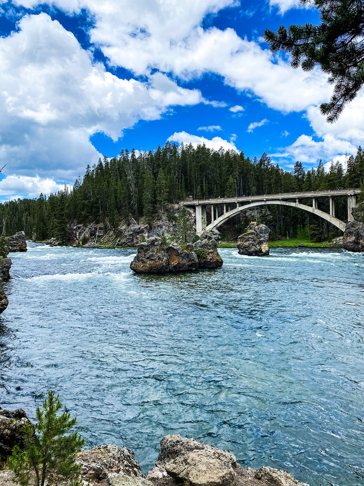
South Rim Trail- From Artist Point, walk to the other end of the parking lot to pick up the South Rim trail. This 3.5-mile roundtrip trail (1.75 miles from Artist Point to the Chittenden Bridge, then another 1.75 miles back) runs parallel with the canyon and Yellowstone River taking you past both falls and past many phenomenal views along the way! This trail is a must see! It was probably our most favorite Yellowstone trail. If you can’t get a parking spot in the Artist Point lot you can park at the other end of the trail at the Wapiti Lake Trailhead lot. Also, if Uncle Tom’s Trail is open when you go (it is currently closed for repair of several unsafe stairs), it is a must do on the South Rim and it is right off the South Rim Trail. It is nicely marked so you can’t miss it!
Hayden Valley- After the South Rim Trail, head back out to Grand Loop Road and head south for 7 miles to drive through the scenic Hayden Valley to Mud Volcano. Hayden Valley, much like Lamar Valley, is a great place to spot lots of wildlife and take in so much beautiful landscape (rolling grassy meadows, rushing sparkling blue water, majestic mountains off in the distance- sounds terrible, right?!) These 7 miles actually took us slightly longer than expected because there were several groups of bison that wanted to hang out right in the middle of the road for a bit so we patiently waited them out😊
Mud Volcano- This trail is a 0.6-mile boardwalk loop over and around very active, muddy, bubbly waters. My kiddos said it was both very cool and very gross, and they could have sat there and watched the crashing of the Dragon’s Mouth Spring all day if it weren’t for the very potent rotten egg smell in this area of the park (caused by the hydrogen sulfide gas)! I would say this trail is moderate in difficulty because of elevation changes- you will have to climb uphill one way and then back down to get back to your car.
Storm Point Hike- After Mud Volcano continue south on Grand Loop Road for 5 miles and then turn left (east) on East Entrance Road (US-14). The trailhead is about 3 miles down East Entrance Road. This easy 2.5-mile loop trail takes you along many different areas-forest, meadows, and to some wonderful views of both Yellowstone Lake and Indian Pond. We all loved this hike, and it is great for all ages!
West Thumb Geyser Basin- After Storm Point, we headed back out to Grand Loop Road and continued south for about 24 miles to the West Thumb Geyser Basin. This easy 1-mile loop trail will take you past so many colorful springs and geysers with gorgeous views of Yellowstone Lake the entire time. There are many trails off of this parking lot but the West Thumb Basin Trail starts off of the northeast corner of the parking lot and is the only boardwalk trail in the area, the others will be dirt trails. This area was chilly and very windy even in the middle of summer so I would take an extra layer before heading out. There are also restrooms and a small bookstore near this trail as well. And that’s the end of day 3!


Day 4
Play catch up- Yellowstone is huge and there is so much to do that the first three days of this itinerary are pretty packed with sights to see and trails to hike. There is a chance between long parking lot waits, traffic on the main roads, impromptu stops for wildlife sightings and closures due to bear activity that even with the most perfectly planned itinerary this park makes it very easy to run short on time. Leave this day as your catch-up day😊 It will make the first three days much less stressful knowing you have an extra day to see anything you missed!
If by chance you have managed to dodge all possible roadblocks, use today to choose your own adventure! Here are a few suggestions😊
#1 Old Faithful Area
-Mystic Falls- This almost 4-mile loop trail starts at the Biscuit Basin Trailhead. Take the Biscuit Basin boardwalk to the split and stay left to get to the Mystic Falls Trailhead. From the Biscuit Basin Trailhead, it’s just over a mile to the Falls. After the Falls continue until you come to the Fairy Creek Trail. Turn right on Fairy Creek Trail to loop back to Biscuit Basin and back to your car. This trail will give you great views of the 70 ft falls as well as an overlook of the entire Upper Geyser Basin. I would say this trail is moderate to strenuous especially with children in tow since there are some steep areas and loose gravel where you’ll need to keep them close.
#2 Mammoth Hot springs Area
-Beaver Ponds Loop- This moderate 5-mile loop trail both starts and ends in Mammoth Hot Springs but the trail ends are about 0.25 miles apart. We started the trail near Liberty Cap and ended near Mammoth Springs Hotel. The trail travels through both forest and meadows (filled with beautiful wildflowers when we were there in the summer) and past the Beaver Ponds. We saw no beavers on this trail, but we did see plenty of elk which was just as lovely! Also, as just a fun fact, you start this trail in Wyoming, hike to Montana, and then end up back in Wyoming😊
#3 Canyon Area
-Ribbon Lake Loop- This trail head will start (follow signs to Clear Lake first) and end at the Uncle Tom’s Point Parking Lot off of South Rim Drive. This trail can be either an out and back or a loop. To complete it as a loop, on your way back from Ribbon Lake, cut over to Lily Pad Lake to head to Artist Point and head back to your car from the South Rim Trail. This is a great way to see several new things but also get one last look at the beautiful Lower Falls and Yellowstone River. Either route is moderate in difficulty and around 6 miles roundtrip😊
#4 West Thumb Area
-Duck Lake- This 1-mile roundtrip trail takes you to a beautiful overlook of Duck Lake and Yellowstone Lake. For the views you will have to do some uphill walking but overall, the entire trail is easy to moderate in difficulty. Our kiddos also loved playing in the sand at the lovely little beach around Duck Lake.
-Lake Overlook- This 1.5-mile loop trail is moderate in difficulty (it does have a 400ft elevation gain) and takes you along some pretty stunning views of Yellowstone Lake. Definitely recommend!


Please reach out if you have any questions!
Hope you have a wonderful adventure!

Leave a Reply